


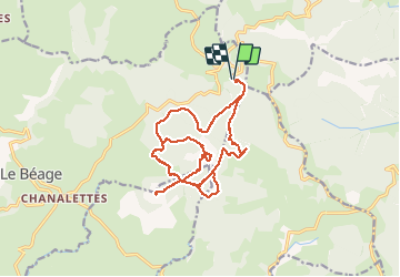
Les 4 sucs

alinetpierre
User

Length
21 km

Max alt
1585 m

Uphill gradient
575 m
Km-Effort
28 km

Min alt
1402 m

Downhill gradient
582 m
Boucle
Yes
Creation date :
2020-06-24 07:08:48.0
Updated on :
2020-06-24 15:04:25.227
7h33
Difficulty : Difficult

FREE GPS app for hiking
 SityTrail
IGN / Geographical institutes
SityTrail Plus
The world is yours!
About
Trail Walking of 21 km to be discovered at Auvergne-Rhône-Alpes, Ardèche, Le Béage. This trail is proposed by alinetpierre.
Description
Cool mais difficile aux intersections car les sentiers nons entretenus , pour cause de coronavirus
Positioning
Country:
France
Region :
Auvergne-Rhône-Alpes
Department/Province :
Ardèche
Municipality :
Le Béage
Location:
Unknown
Start:(Dec)
Start:(UTM)
593460 ; 4969199 (31T) N.
Comments